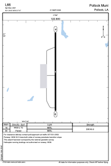


L66 - Pollock Muni
Located in Pollock, United States
ICAO - L66, IATA -
Data provided by AirmateGeneral information
Coordinates: N31°28'39" W92°27'40"
Elevation is 203 feet MSL.
Magnetic variation is 04° East View others Airports in Louisiana
Operational data
Special qualification required
Current time UTC:
Current local time:
Weather at : KESF - Esler Rgnl ( 18 km )
METAR: KESF 132232Z AUTO 00000KT 5SM VCTS -RA BR FEW015 SCT085 OVC110 24/23 A2971 RMK AO2 LTG DSNT ALQDS RAB2157 TSB11E26 P0001 T02390228
Communications frequencies: [VIEW]
Runways:
| RWY identifier | QFU | Length (ft) | Width (ft) | Surface | LDA (ft) |
| 18 | 180° | 4499 | 75 | ASPH | |
| 36 | 0° | 4499 | 75 | ASPH |
Airport contact information
Address: Pollock United States
