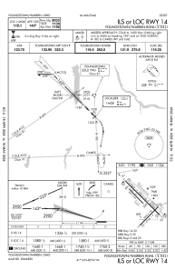
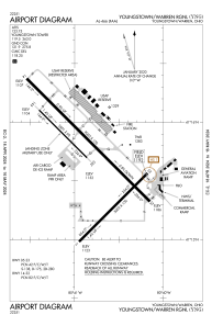


KYNG - Youngstown/Warren Rgnl
Located in Youngstown/Warren, United States
ICAO - YNG, IATA - YNG
Data provided by AirmateGeneral information
Coordinates: N41°15'42" W80°40'49"
Elevation is 1191 feet MSL.
Magnetic variation is -08° East View others Airports in Ohio
Operational data
Special qualification required
Current time UTC:
Current local time:
Weather
METAR: KYNG 271151Z 15010KT 10SM SCT047 BKN055 BKN080 OVC140 12/09 A3019 RMK AO2 LTG DSNT NE AND W SLP222 60003 70003 T01220089 10144 20106 53002
TAF: KYNG 271123Z 2712/2812 15012G21KT P6SM -SHRA VCTS BKN050CB TEMPO 2712/2714 5SM -TSRA BKN035CB FM271500 18013G20KT P6SM BKN030 FM271800 19013G20KT P6SM BKN035 FM272300 19010KT P6SM BKN100
Communications frequencies: [VIEW]
Runways:
| RWY identifier | QFU | Length (ft) | Width (ft) | Surface | LDA (ft) |
| 05 | 45° | 5002 | 150 | ASPH | 5002 |
| 23 | 225° | 5002 | 150 | ASPH | 5002 |
| 14 | 135° | 9003 | 150 | ASPH | 9003 |
| 32 | 315° | 9003 | 150 | ASPH | 9003 |
| 143 | 135° | 3501 | 60 | ASPH | 3500 |
| 323 | 315° | 3501 | 60 | ASPH | 3500 |
Airport contact information
Address: Youngstown/Warren United States