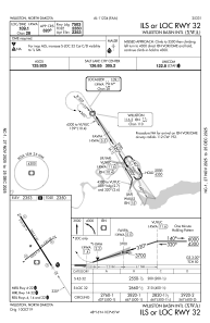
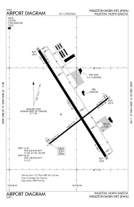


KXWA - Williston Basin Intl
Located in Williston, United States
ICAO - XWA, IATA -
Data provided by AirmateGeneral information
Coordinates: N48°15'35" W103°45'2"
Elevation is 2356 feet MSL.
Magnetic variation is 08° East View others Airports in North Dakota
Operational data
Special qualification required
Current time UTC:
Current local time:
Weather
METAR: KXWA 290551Z AUTO 09007KT 10SM CLR 03/M01 A2985 RMK AO2 SLP128 T00281011 10128 20022 401610011 58006
TAF: KXWA 290530Z 2906/3006 15009KT P6SM SKC FM291500 19007KT P6SM FEW009 SCT150 FM291800 24008KT P6SM FEW150 FM300400 14009KT P6SM SCT150
Communications frequencies: [VIEW]
Runways:
| RWY identifier | QFU | Length (ft) | Width (ft) | Surface | LDA (ft) |
| 14 | 148° | 7503 | 150 | CONC | 7503 |
| 32 | 328° | 7503 | 150 | CONC | 7503 |
| 04 | 52° | 4502 | 75 | CONC | 4502 |
| 22 | 232° | 4502 | 75 | CONC | 4502 |
Airport contact information
Address: Williston United States