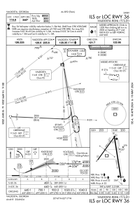
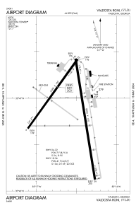


KVLD - Valdosta Rgnl
Located in Valdosta, United States
ICAO - VLD, IATA - VLD
Data provided by AirmateGeneral information
Coordinates: N30°46'53" W83°16'33"
Elevation is 203 feet MSL.
Magnetic variation is -05° East View others Airports in Georgia
Operational data
Special qualification required
Current time UTC:
Current local time:
Weather
METAR: KVLD 302053Z 19008KT 10SM SCT050 SCT065 31/18 A2994 RMK AO2 SLP143 T03110178 58024
TAF: KVLD 301739Z 3018/0118 21006KT P6SM SCT045 BKN100 FM010000 20003KT P6SM BKN250 FM010900 00000KT 5SM BR SCT007 TEMPO 0111/0113 OVC007 FM011300 27003KT P6SM FEW007
Communications frequencies: [VIEW]
Runways:
| RWY identifier | QFU | Length (ft) | Width (ft) | Surface | LDA (ft) |
| 04 | 36° | 5598 | 100 | ASPH | |
| 22 | 216° | 5598 | 100 | ASPH | |
| 18 | 171° | 8002 | 150 | ASPH | |
| 36 | 351° | 8002 | 150 | ASPH |
Airport contact information
Address: Valdosta United States
