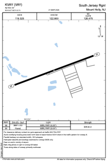


KVAY - South Jersey Rgnl
Located in Mount Holly, United States
ICAO - VAY, IATA - LLY
Data provided by AirmateGeneral information
Coordinates: N39°56'34" W74°50'45"
Elevation is 52 feet MSL.
Magnetic variation is -12° East View others Airports in New Jersey
Operational data
Special qualification required
Current time UTC:
Current local time:
Weather
METAR: KVAY 120854Z AUTO 00000KT 7SM RA OVC049 08/07 A2986 RMK AO2 SLP112 P0004 60004 T00830067 53006
Communications frequencies: [VIEW]
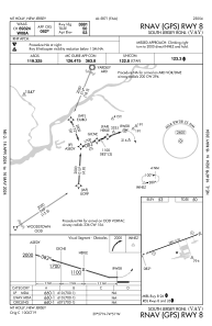
Runways:
| RWY identifier | QFU | Length (ft) | Width (ft) | Surface | LDA (ft) |
| 08 | 70° | 3881 | 50 | ASPH | |
| 26 | 250° | 3881 | 50 | ASPH |
Airport contact information
Address: Mount Holly United States
