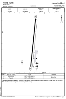


KUTS - Huntsville Muni
Located in Huntsville, United States
ICAO - UTS, IATA - HTV
Data provided by AirmateGeneral information
Coordinates: N30°44'49" W95°35'14"
Elevation is 362 feet MSL.
Magnetic variation is 06° East View others Airports in Texas
Operational data
Special qualification required
Current time UTC:
Current local time:
Weather
METAR: KUTS 282329Z AUTO 15010G22KT 1 1/2SM +TSRA BR FEW006 BKN018 OVC027 24/23 A2977 RMK AO2 PK WND 13028/2254 LTG DSNT ALQDS RAB20 TSB18 P0016 T02440228 $
TAF: KUTS 282320Z 2900/2924 14013G23KT 6SM SHRA BR VCTS BKN025 OVC035CB TEMPO 2900/2904 VRB35KT 1SM TSRA BR BKN015CB FM290800 VRB04KT 6SM BR BKN010 FM291500 25005KT P6SM BKN012 FM291700 27005KT P6SM SCT025 BKN035 FM292100 34004KT P6SM SCT060
Communications frequencies: [VIEW]
Runways:
| RWY identifier | QFU | Length (ft) | Width (ft) | Surface | LDA (ft) |
| 18 | 186° | 5005 | 100 | ASPH | |
| 36 | 6° | 5005 | 100 | ASPH |
Airport contact information
Address: Huntsville United States
