


KUNV - University Park
Located in State College, United States
ICAO - UNV, IATA - SCE
Data provided by AirmateGeneral information
Coordinates: N40°51'0" W77°50'51"
Elevation is 1231 feet MSL.
Magnetic variation is -11° East View others Airports in Pennsylvania
Operational data
Special qualification required
Current time UTC:
Current local time:
Weather
METAR: KUNV 261953Z 16009KT 10SM CLR 16/02 A3033
TAF: KUNV 261724Z 2618/2718 19006G14KT P6SM SKC FM270200 17004KT P6SM SCT070 BKN250 FM271100 19004KT P6SM BKN070 OVC150 FM271300 19006KT P6SM OVC060 FM271400 18006KT 4SM -SHRA BR OVC025 FM271700 17006KT 2SM -SHRA BR OVC015
Communications frequencies: [VIEW]
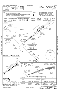
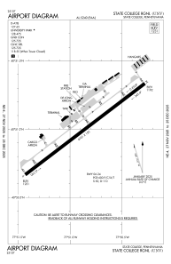
Runways:
| RWY identifier | QFU | Length (ft) | Width (ft) | Surface | LDA (ft) |
| 06 | 53° | 6701 | 150 | ASPH | 6701 |
| 24 | 233° | 6701 | 150 | ASPH | 6701 |
Airport contact information
Address: State College United States
Other aviation service providers
Flight schools

Tech Aviation Flight School, Inc.
Tech Aviation Flight School, Inc.
info@techaviationflightschool.com5704142931