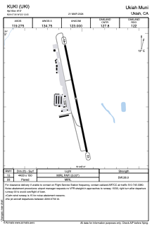


KUKI - Ukiah Muni
Located in Ukiah, United States
ICAO - UKI, IATA -
Data provided by AirmateGeneral information
Coordinates: N39°7'33" W123°12'3"
Elevation is 616 feet MSL.
Magnetic variation is 13° East View others Airports in California
Operational data
Special qualification required
Current time UTC:
Current local time:
Weather
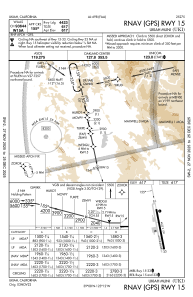
METAR: KUKI 271256Z AUTO 00000KT 10SM CLR 06/04 A3008 RMK AO2 SLP185 T00610039
TAF: KUKI 271137Z 2712/2812 36004KT 6SM BR FEW010 FM272100 31010G18KT P6SM SCT250 FM280200 34005KT P6SM SCT100 BKN250
Communications frequencies: [VIEW]
Runways:
| RWY identifier | QFU | Length (ft) | Width (ft) | Surface | LDA (ft) |
| 15 | 168° | 4423 | 150 | ASPH | |
| 33 | 348° | 4423 | 150 | ASPH |
Airport contact information
Address: Ukiah United States
