


KUIN - Quincy Rgnl-Baldwin Fld
Located in Quincy, United States
ICAO - UIN, IATA - UIN
Data provided by AirmateGeneral information
Coordinates: N39°56'32" W91°11'33"
Elevation is 768 feet MSL.
Magnetic variation is 02° East View others Airports in Illinois
Operational data
Special qualification required
Current time UTC:
Current local time:
Weather
METAR: KUIN 010054Z AUTO 15008KT 10SM CLR 23/12 A2974 RMK AO2 SLP065 T02330122 $
TAF: KUIN 302329Z 0100/0124 16013G20KT P6SM BKN250 FM010400 18014G23KT 6SM SHRA BR VCTS OVC090CB FM010700 24007KT P6SM SCT250 FM011300 35009KT P6SM SCT250 FM011800 03006KT P6SM FEW060
Communications frequencies: [VIEW]
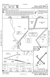
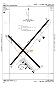
Runways:
| RWY identifier | QFU | Length (ft) | Width (ft) | Surface | LDA (ft) |
| 04 | 40° | 7098 | 150 | ASPH | 7098 |
| 22 | 220° | 7098 | 150 | ASPH | 7098 |
| 13 | 135° | 5397 | 150 | ASPH | 5123 |
| 31 | 315° | 5397 | 150 | ASPH | 5146 |
Airport contact information
Address: Quincy United States
