


KUES - Waukesha County
Located in Waukesha, United States
ICAO - UES, IATA -
Data provided by AirmateGeneral information
Coordinates: N43°2'28" W88°14'13"
Elevation is 911 feet MSL.
Magnetic variation is -01° East View others Airports in Wisconsin
Operational data
Special qualification required
Current time UTC:
Current local time:
Weather
METAR: KUES 281245Z 05008G14KT 10SM OVC006 09/09 A2998
TAF: KUES 281140Z 2812/2912 06012KT 4SM -SHRA BR OVC017 FM281400 06012KT 4SM -SHRA BR OVC005 TEMPO 2819/2823 2SM TSRA BR OVC005CB FM282300 07008KT 4SM SHRA BR OVC005 PROB30 2823/2824 2SM TSRA BR OVC005CB FM290000 06007KT P6SM OVC004 PROB30 2900/2906 4SM TSRA BR OVC005CB FM290600 16008KT 3SM SHRA BR OVC004
Communications frequencies: [VIEW]
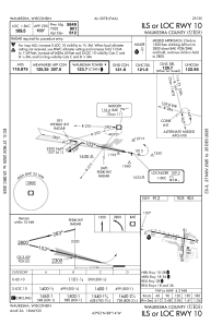
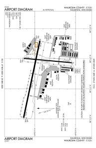
Runways:
| RWY identifier | QFU | Length (ft) | Width (ft) | Surface | LDA (ft) |
| 10 | 102° | 5849 | 100 | CONC | |
| 28 | 282° | 5849 | 100 | CONC | |
| 18 | 185° | 3599 | 75 | ASPH | |
| 36 | 5° | 3599 | 75 | ASPH |
Airport contact information
Address: Waukesha United States

