


KTYS - Mc Ghee Tyson
Located in Knoxville, United States
ICAO - TYS, IATA - TYS
Data provided by AirmateGeneral information
Coordinates: N35°48'40" W83°59'39"
Elevation is 986 feet MSL.
Magnetic variation is -06° East View others Airports in Tennessee
Operational data
Special qualification required
Current time UTC:
Current local time:
Weather
METAR: KTYS 301353Z 11005KT 10SM SCT080 OVC100 17/16 A2999 RMK AO2 RAE1256B24E50 SLP149 P0001 T01720156
TAF: KTYS 301403Z 3014/0112 11005KT P6SM VCSH SCT080 OVC100 FM301700 23009KT P6SM VCSH BKN035 TEMPO 3017/3021 -SHRA OVC035 FM010000 VRB03KT P6SM SCT035 FM010800 00000KT 4SM BR SKC FM011000 00000KT 1/2SM FG BKN002
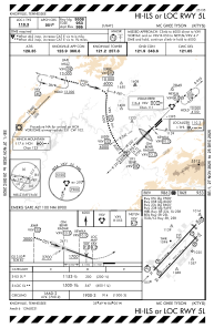
Communications frequencies: [VIEW]
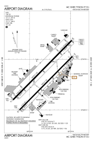
Runways:
| RWY identifier | QFU | Length (ft) | Width (ft) | Surface | LDA (ft) |
| 05L | 45° | 10000 | 150 | CONC | 9508 |
| 23R | 225° | 10000 | 150 | CONC | 9495 |
| 05R | 45° | 9000 | 150 | ASPH | 8600 |
| 23L | 225° | 9000 | 150 | ASPH | 8600 |
Airport contact information
Address: Knoxville United States