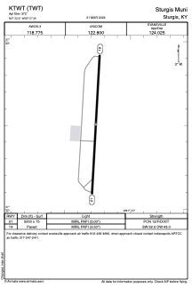


KTWT - Sturgis Muni
Located in Sturgis, United States
ICAO - TWT, IATA -
Data provided by AirmateGeneral information
Coordinates: N37°32'30" W87°57'16"
Elevation is 372 feet MSL.
Magnetic variation is 00° East View others Airports in Kentucky
Operational data
Special qualification required
Current time UTC:
Current local time:
Weather at : KEHR - Henderson City-County ( 38 km )
METAR: KEHR 142307Z AUTO 01007KT 10SM BKN020 OVC036 21/19 A2960 RMK AO2 LTG DSNT NE AND E TSE01
Communications frequencies: [VIEW]
Runways:
| RWY identifier | QFU | Length (ft) | Width (ft) | Surface | LDA (ft) |
| 01 | 3° | 5000 | 75 | ASPH | |
| 19 | 183° | 5000 | 75 | ASPH |
Airport contact information
Address: Sturgis United States