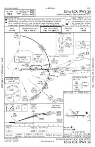
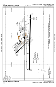


KTWF - Joslin Fld/Magic Valley Rgnl
Located in Twin Falls, United States
ICAO - TWF, IATA - TWF
Data provided by AirmateGeneral information
Coordinates: N42°28'55" W114°29'16"
Elevation is 4153 feet MSL.
Magnetic variation is 13° East View others Airports in Idaho
Operational data
Special qualification required
Current time UTC:
Current local time:
Weather
METAR: KTWF 281553Z 28016KT 10SM CLR 10/M01 A3007 RMK AO2 PK WND 27027/1510 SLP162 T01001006
TAF: KTWF 281120Z 2812/2912 24014KT P6SM SCT070 FM281400 26016G24KT P6SM SCT250 FM290100 28009KT P6SM SCT200 FM290300 19009KT P6SM BKN200
Communications frequencies: [VIEW]
Runways:
| RWY identifier | QFU | Length (ft) | Width (ft) | Surface | LDA (ft) |
| 12 | 136° | 3224 | 75 | ASPH | |
| 30 | 316° | 3224 | 75 | ASPH | |
| 08 | 91° | 8704 | 150 | ASPH | |
| 26 | 271° | 8704 | 150 | ASPH |
Airport contact information
Address: Twin Falls United States

