


KTOI - Troy Muni At N Kenneth Campbell Fld
Located in Troy, United States
ICAO - TOI, IATA -
Data provided by AirmateGeneral information
Coordinates: N31°51'36" W86°0'50"
Elevation is 397 feet MSL.
Magnetic variation is -04° East View others Airports in Alabama
Operational data
Special qualification required
Current time UTC:
Current local time:
Weather
METAR: KTOI 271853Z AUTO 13006G16KT 10SM FEW047 SCT060 27/16 A3022 RMK AO2 SLP228 T02670156
TAF: KTOI 271720Z 2718/2818 15010G18KT P6SM BKN060 FM280200 VRB04KT P6SM OVC250 FM281500 14010G18KT P6SM BKN050
Communications frequencies: [VIEW]
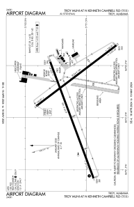
Runways:
| RWY identifier | QFU | Length (ft) | Width (ft) | Surface | LDA (ft) |
| 07 | 69° | 6197 | 100 | ASPH | |
| 25 | 250° | 6197 | 100 | ASPH | |
| 14 | 143° | 5024 | 100 | ASPH | |
| 32 | 323° | 5024 | 100 | ASPH |
Airport contact information
Address: Troy United States
