


KTIK - Tinker Afb
Located in Oklahoma City, United States
ICAO - TIK, IATA -
Data provided by AirmateGeneral information
Coordinates: N35°24'53" W97°23'12"
Elevation is 1290 feet MSL.
Magnetic variation is 03° East View others Airports in Oklahoma
Operational data
Special qualification required
Current time UTC:
Current local time:
Weather
METAR: KTIK 081455Z 23013G21KT 10SM SCT022 26/19 A2949 RMK AO2A SLP981 T02600194 $
TAF: TAF KTIK 080900Z 0809/0915 18012KT 9999 SCT015 WS020/22045KT QNH2946INS BECMG 0811/0812 22009KT 4800 BR OVC010 QNH2950INS BECMG 0814/0815 VRB06KT 8000 BR BKN010 QNH2955INS BECMG 0817/0818 33012KT 9999 NSW SKC QNH2959INS TX25/0820Z TN15/0811Z
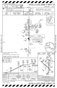
Communications frequencies: [VIEW]
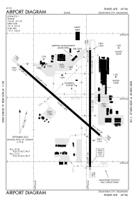
Runways:
| RWY identifier | QFU | Length (ft) | Width (ft) | Surface | LDA (ft) |
| 13 | 131° | 10000 | 200 | OTHER | |
| 31 | 311° | 10000 | 200 | OTHER | |
| 18 | 180° | 11100 | 200 | OTHER | |
| 36 | 360° | 11100 | 200 | OTHER |
Airport contact information
Address: Oklahoma City United States