


KTBN - Waynesville-St Robert Rgnl Forney Fld
Located in Fort Leonard Wood, United States
ICAO - TBN, IATA - TBN
Data provided by AirmateGeneral information
Coordinates: N37°44'30" W92°8'27"
Elevation is 1159 feet MSL.
Magnetic variation is 00° East View others Airports in Missouri
Operational data
Special qualification required
Current time UTC:
Current local time:
Weather
TAF: TAF KTBN 031159Z 0312/0418 01006KT 8000 -RA OVC006 QNH2998INS BECMG 0316/0318 04006KT 8000 BR SCT006 OVC014 QNH2999INS BECMG 0318/0320 06006KT 9000 BR FEW014 BKN022 BKN029 QNH2998INS BECMG 0403/0405 11006KT 9999 RA BKN022 OVC029 QNH2996INS BECMG 0407/0409 14006KT 8000 RA SCT006 BKN014 OVC021 QNH2994INS BECMG 0410/0412 15006KT 8000 RA BKN006 OVC013 QNH2990INS BECMG 0413/0415 18003KT 8000 -SHRA SCT006 SCT014 BKN021 BKN029 BKN046 QNH2996INS BECMG 0415/0417 16009KT 9000 RA BKN014 OVC021 QNH2996INS BECMG 0416/0418 19006KT 9999 -RA BKN022 OVC030 QNH2997INS TX22/0321Z TN16/0312Z
Communications frequencies: [VIEW]
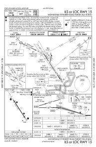
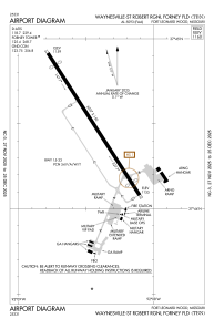
Runways:
| RWY identifier | QFU | Length (ft) | Width (ft) | Surface | LDA (ft) |
| 15 | 147° | 6037 | 150 | ASPH | |
| 33 | 327° | 6037 | 150 | ASPH |
Airport contact information
Address: Fort Leonard Wood United States