


KSYM - Morehead-Rowan County Clyde A Thomas Rgnl
Situé à Morehead, United States
ICAO - SYM, IATA -
Données fournies par AirmateInformation générale
Coordonnées: N38°12'54" W83°35'15"
Élévation : 1028 feet MSL.
Variation magnétique : -06° East Voir autres Aéroports à Kentucky
Données opérationnelles
Special qualification required
Heure actuelle UTC:
Heure actuelle locale:
Météo
METAR: KSYM 160515Z AUTO 00000KT 10SM BKN006 OVC013 17/17 A2981 RMK AO2
TAF: KSYM 160441Z 1605/1624 VRB03KT 4SM BR BKN007 FM160800 VRB03KT 1 1/2SM BR SCT001 BKN003 FM161300 VRB03KT 4SM BR SCT001 BKN003 FM161400 VRB03KT P6SM SCT003 BKN007 FM161600 VRB04KT P6SM FEW015 SCT025
Fréquences de communication: [VIEW]
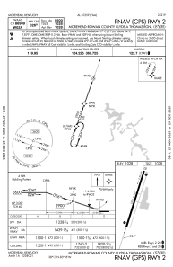
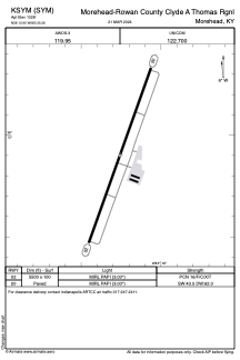
Pistes:
| Identifiant RWY | QFU | Longueur (ft) | Largeur (ft) | Surface | LDA (ft) |
| 02 | 20° | 5500 | 100 | ASPH | |
| 20 | 200° | 5500 | 100 | ASPH |
Coordonnées de l'aéroport
Adresse: Morehead United States