


KSUS - Spirit Of St Louis
Located in St Louis, United States
ICAO - SUS, IATA -
Data provided by AirmateGeneral information
Coordinates: N38°39'44" W90°39'7"
Elevation is 463 feet MSL.
Magnetic variation is -01° East View others Airports in Missouri
Operational data
Special qualification required
Current time UTC:
Current local time:
Weather
METAR: KSUS 281054Z 18008G18KT 10SM CLR 21/17 A2986 RMK AO2 SLP106 T02110167
TAF: KSUS 280939Z 2810/2906 18008KT P6SM BKN110 FM281500 19014G24KT P6SM BKN035 FM290000 17011G19KT 6SM SHRA BR VCTS OVC030CB FM290400 21012G21KT 6SM BR VCTS OVC040CB
Communications frequencies: [VIEW]
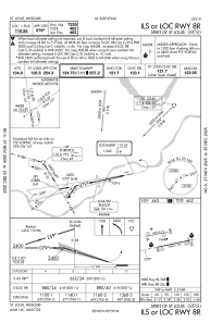
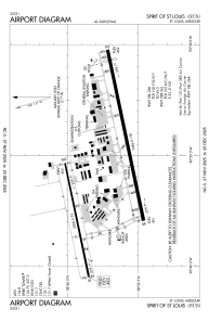
Runways:
| RWY identifier | QFU | Length (ft) | Width (ft) | Surface | LDA (ft) |
| 08R | 78° | 7485 | 150 | CONC | 7414 |
| 26L | 258° | 7485 | 150 | CONC | 7004 |
| 08L | 78° | 5000 | 75 | ASPH | 5000 |
| 26R | 258° | 5000 | 75 | ASPH | 5000 |
Airport contact information
Address: St Louis United States
