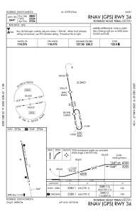
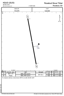


KSUO - Rosebud Sioux Tribal
Located in Rosebud, United States
ICAO - SUO, IATA -
Data provided by AirmateGeneral information
Coordinates: N43°15'30" W100°51'34"
Elevation is 2724 feet MSL.
Magnetic variation is 06° East View others Airports in South Dakota
Operational data
Special qualification required
Current time UTC:
Current local time:
Weather at : KVTN - Miller Fld ( 51 km )
METAR: KVTN 142052Z AUTO 15014G29KT 9SM FEW080 28/08 A2968 RMK AO2 PK WND 16029/2031 SLP035 T02780083 58020
TAF: KVTN 141720Z 1418/1518 16013G21KT P6SM FEW250 FM142200 25013KT P6SM VCTS BKN100CB TEMPO 1422/1502 4SM TSRA BR OVC025CB FM150500 28008KT P6SM BKN020 FM151500 31010KT P6SM SCT020
Communications frequencies: [VIEW]
Runways:
| RWY identifier | QFU | Length (ft) | Width (ft) | Surface | LDA (ft) |
| 16 | 170° | 4801 | 75 | CONC | 4800 |
| 34 | 350° | 4801 | 75 | CONC | 4800 |
Airport contact information
Address: Rosebud United States