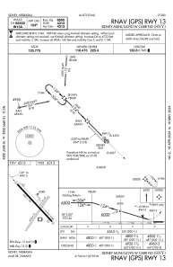
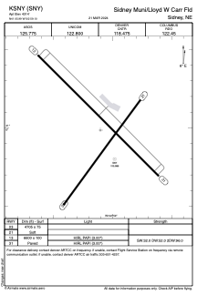


KSNY - Sidney Muni/Lloyd W Carr Fld
Located in Sidney, United States
ICAO - SNY, IATA -
Data provided by AirmateGeneral information
Coordinates: N41°5'59" W102°59'6"
Elevation is 4314 feet MSL.
Magnetic variation is 11° East View others Airports in Nebraska
Operational data
Special qualification required
Current time UTC:
Current local time:
Weather
METAR: KSNY 291453Z AUTO 29012KT 10SM CLR 13/03 A2992 RMK AO2 SLP121 T01280033 51012
TAF: KSNY 291122Z 2912/3012 29010KT P6SM FEW250 FM291900 28010G20KT P6SM SCT200 FM300000 17009KT P6SM BKN100
Communications frequencies: [VIEW]
Runways:
| RWY identifier | QFU | Length (ft) | Width (ft) | Surface | LDA (ft) |
| 03 | 36° | 4705 | 75 | GRASS | |
| 21 | 216° | 4705 | 75 | GRASS | |
| 13 | 135° | 6600 | 100 | CONC | |
| 31 | 315° | 6600 | 100 | CONC |
Airport contact information
Address: Sidney United States