


KSMF - Sacramento Intl
Located in Sacramento, United States
ICAO - SMF, IATA - SMF
Data provided by AirmateGeneral information
Coordinates: N38°41'44" W121°35'27"
Elevation is 26 feet MSL.
Magnetic variation is 13° East View others Airports in California
Operational data
Special qualification required
Current time UTC:
Current local time:
Weather
METAR: KSMF 281453Z 00000KT 10SM CLR 13/09 A3009 RMK AO2 SLP190 T01330094 53011 $
TAF: KSMF 281120Z 2812/2912 17006KT P6SM FEW250
Communications frequencies: [VIEW]
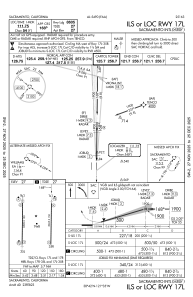
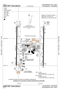
Runways:
| RWY identifier | QFU | Length (ft) | Width (ft) | Surface | LDA (ft) |
| 17L | 181° | 8605 | 150 | CONC | 8605 |
| 35R | 1° | 8605 | 150 | CONC | 8605 |
| 17R | 181° | 8598 | 150 | CONC | 8598 |
| 35L | 1° | 8598 | 150 | CONC | 8598 |
Airport contact information
Address: Sacramento United States