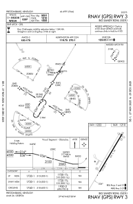
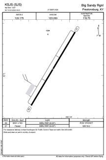


KSJS - Big Sandy Rgnl
Located in Prestonsburg, United States
ICAO - SJS, IATA -
Data provided by AirmateGeneral information
Coordinates: N37°45'3" W82°38'12"
Elevation is 1221 feet MSL.
Magnetic variation is -05° East View others Airports in Kentucky
Operational data
Special qualification required
Current time UTC:
Current local time:
Weather
METAR: KSJS 111555Z AUTO 26005G16KT 10SM SCT040 BKN090 OVC110 18/09 A2986 RMK AO2 T01790094
TAF: KSJS 111138Z 1112/1212 VRB04KT 2SM BR SCT003 BKN035 TEMPO 1112/1114 1/4SM FG BKN002 FM111400 24009KT P6SM SCT070 FM111700 26011KT P6SM -SHRA BKN035 FM112200 29011KT P6SM FEW200 FM120200 VRB05KT P6SM FEW250
Communications frequencies: [VIEW]
Runways:
| RWY identifier | QFU | Length (ft) | Width (ft) | Surface | LDA (ft) |
| 03 | 31° | 5051 | 100 | ASPH | |
| 21 | 211° | 5051 | 100 | ASPH |
Airport contact information
Address: Prestonsburg United States