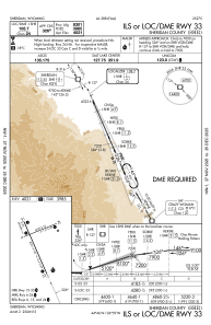
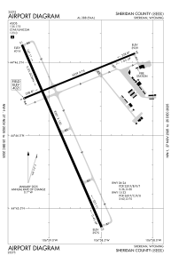


KSHR - Sheridan County
Located in Sheridan, United States
ICAO - SHR, IATA - SHR
Data provided by AirmateGeneral information
Coordinates: N44°46'9" W106°58'49"
Elevation is 4021 feet MSL.
Magnetic variation is 10° East View others Airports in Wyoming
Operational data
Special qualification required
Current time UTC:
Current local time:
Weather
METAR: KSHR 030153Z AUTO 34010KT 10SM OVC050 07/M04 A2993 RMK AO2 SLP141 T00721039
TAF: KSHR 022320Z 0300/0324 32016G24KT P6SM VCSH BKN050 FM030100 32012KT P6SM VCSH SCT050 OVC080 FM030300 VRB06KT P6SM BKN080 FM031500 32012G22KT P6SM BKN060
Communications frequencies: [VIEW]
Runways:
| RWY identifier | QFU | Length (ft) | Width (ft) | Surface | LDA (ft) |
| 06 | 68° | 5039 | 75 | ASPH | 5039 |
| 24 | 248° | 5039 | 75 | ASPH | 5039 |
| 15 | 156° | 8301 | 100 | ASPH | 8301 |
| 33 | 336° | 8301 | 100 | ASPH | 8301 |
Airport contact information
Address: Sheridan United States
