


KSAT - San Antonio Intl
Located in San Antonio, United States
ICAO - SAT, IATA - SAT
Data provided by AirmateGeneral information
Coordinates: N29°32'2" W98°28'9"
Elevation is 809 feet MSL.
Magnetic variation is 04° East View others Airports in Texas
Operational data
Special qualification required
Current time UTC:
Current local time:
Weather
METAR: KSAT 281203Z 31011KT 1 1/2SM R13R/3000VP6000FT +TSRA BR SCT018 BKN025CB OVC047 19/17 A2984 RMK AO2 LTG DSNT ALQDS PRESRR OCNL LTGICCG TS NW MOV E P0005 T01940172
TAF: KSAT 281120Z 2812/2918 VRB06KT P6SM VCTS OVC020CB TEMPO 2812/2816 VRB25G35KT 3SM -TSRA OVC020CB FM281800 12006KT P6SM BKN020 FM282100 11005KT P6SM SCT050 FM290600 VRB03KT P6SM BKN015 FM291200 VRB03KT 4SM BR BKN007 FM291500 12005KT P6SM BKN015 FM291700 12005KT P6SM BKN025
Communications frequencies: [VIEW]
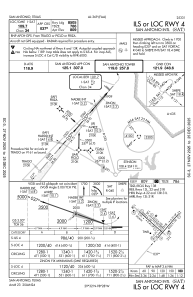
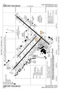
Runways:
| RWY identifier | QFU | Length (ft) | Width (ft) | Surface | LDA (ft) |
| 04 | 41° | 8505 | 150 | CONC | 8505 |
| 22 | 221° | 8505 | 150 | CONC | 8505 |
| 13L | 132° | 5519 | 100 | ASPH | 5519 |
| 31R | 312° | 5519 | 100 | ASPH | 5519 |
| 13R | 132° | 8502 | 150 | CONC | 8502 |
| 31L | 312° | 8502 | 150 | CONC | 8502 |
Airport contact information
Address: San Antonio United States
Other aviation service providers
Flight schools

Alpha Tango Flying Services, Inc.
Alpha Tango Flying Services, Inc.
alpha.tango@sbcglobal.net2108284480