


KSAF - Santa Fe Rgnl
Located in Santa Fe, United States
ICAO - SAF, IATA - SAF
Data provided by AirmateGeneral information
Coordinates: N35°37'2" W106°5'22"
Elevation is 6348 feet MSL.
Magnetic variation is 08° East View others Airports in New Mexico
Operational data
Special qualification required
Current time UTC:
Current local time:
Weather
METAR: KSAF 091853Z 16020G26KT 10SM BKN100 19/M04 A3000 RMK AO2 PK WND 14033/1813 SLP080 T01941039
TAF: KSAF 091735Z 0918/1018 14015G25KT P6SM SCT110 FM092200 13018G30KT P6SM BKN120 FM100700 12028G40KT P6SM SCT110 FM101100 13025G33KT P6SM BKN060 FM101500 13020G31KT P6SM BKN025
Communications frequencies: [VIEW]
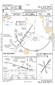
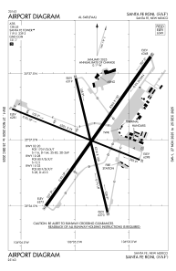
Runways:
| RWY identifier | QFU | Length (ft) | Width (ft) | Surface | LDA (ft) |
| 02 | 35° | 8366 | 150 | ASPH | |
| 20 | 215° | 8366 | 150 | ASPH | |
| 10 | 112° | 6301 | 75 | ASPH | |
| 28 | 292° | 6301 | 75 | ASPH | |
| 15 | 167° | 6316 | 100 | ASPH | 5221 |
| 33 | 347° | 6316 | 100 | ASPH |
Airport contact information
Address: Santa Fe United States

