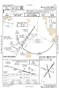
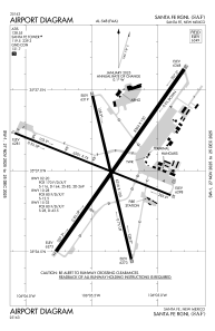


KSAF - Santa Fe Muni
Located in Santa Fe, United States
ICAO - SAF, IATA - SAF
Data provided by AirmateGeneral information
Coordinates: N35°37'2" W106°5'22"
Elevation is 6348 feet MSL.
Magnetic variation is 08° East View others Airports in New Mexico
Operational data
Special qualification required
Current time UTC:
Current local time:
Weather
METAR: KSAF 270553Z AUTO 26004KT 10SM CLR 12/M06 A2973 RMK AO2 SLP989 T01171061 10183 20117 50006
TAF: KSAF 270542Z 2706/2806 25007KT P6SM SCT110 BKN200 FM270800 33006KT P6SM BKN200 FM271600 23014G23KT P6SM FEW040 SCT100 FM272000 24014G26KT P6SM VCSH BKN035 TEMPO 2720/2723 -SHRA BKN025 FM280000 28008KT P6SM VCSH BKN040
Communications frequencies: [VIEW]
Runways:
| RWY identifier | QFU | Length (ft) | Width (ft) | Surface | LDA (ft) |
| 02 | 35° | 8366 | 150 | ASPH | |
| 20 | 215° | 8366 | 150 | ASPH | |
| 10 | 112° | 6301 | 75 | ASPH | |
| 28 | 292° | 6301 | 75 | ASPH | |
| 15 | 167° | 6316 | 100 | ASPH | 5221 |
| 33 | 347° | 6316 | 100 | ASPH |
Airport contact information
Address: Santa Fe United States

