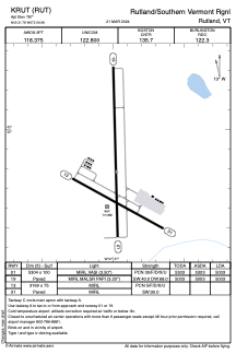


KRUT - Rutland/Southern Vermont Rgnl
Located in Rutland, United States
ICAO - RUT, IATA - RUT
Data provided by AirmateGeneral information
Coordinates: N43°31'47" W72°56'59"
Elevation is 787 feet MSL.
Magnetic variation is -15° East View others Airports in Vermont
Operational data
Special qualification required
Current time UTC:
Current local time:
Weather
METAR: KRUT 280256Z AUTO 00000KT 10SM -RA BKN042 BKN065 OVC085 11/06 A3025 RMK AO2 SLP239 P0000 60000 T01110061 50002 $
TAF: KRUT 272320Z 2800/2824 19006KT P6SM VCSH OVC130 FM280500 16005KT P6SM -SHRA BKN025 FM281200 VRB04KT P6SM BKN016 FM281500 20005KT P6SM BKN022 FM281700 23006KT P6SM BKN045
Communications frequencies: [VIEW]
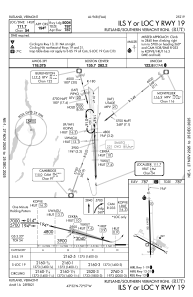
Runways:
| RWY identifier | QFU | Length (ft) | Width (ft) | Surface | LDA (ft) |
| 01 | 359° | 5304 | 100 | ASPH | 5003 |
| 19 | 179° | 5304 | 100 | ASPH | 5003 |
| 13 | 119° | 3169 | 75 | ASPH | |
| 31 | 299° | 3169 | 75 | ASPH |
Airport contact information
Address: Rutland United States