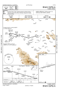
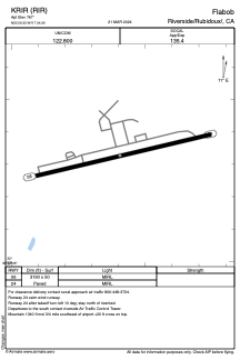


KRIR - Flabob
Located in Riverside/Rubidoux/, United States
ICAO - RIR, IATA -
Data provided by AirmateGeneral information
Coordinates: N33°59'20" W117°24'36"
Elevation is 767 feet MSL.
Magnetic variation is 13° East View others Airports in California
Operational data
Special qualification required
Current time UTC:
Current local time:
Weather at : KRAL - Riverside Muni ( 5 km )
METAR: KRAL 290053Z 27012KT 10SM CLR 23/10 A2991 RMK AO2 SLP115 T02280100
Communications frequencies: [VIEW]
Runways:
| RWY identifier | QFU | Length (ft) | Width (ft) | Surface | LDA (ft) |
| 06 | 77° | 3190 | 50 | ASPH | |
| 24 | 257° | 3190 | 50 | ASPH |
Airport contact information
Address: Riverside/Rubidoux/ United States