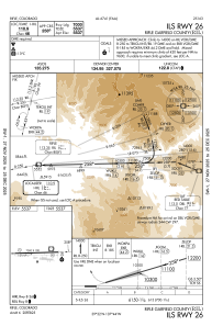
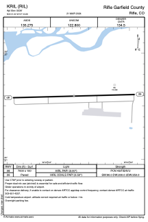


KRIL - Rifle Garfield County
Located in Rifle, United States
ICAO - RIL, IATA -
Data provided by AirmateGeneral information
Coordinates: N39°31'36" W107°43'41"
Elevation is 5536 feet MSL.
Magnetic variation is 10° East View others Airports in Colorado
Operational data
Special qualification required
Current time UTC:
Current local time:
Weather
METAR: KRIL 301653Z AUTO 00000KT 10SM CLR 20/03 A3010 RMK AO2 SLP137 T02000028
TAF: KRIL 301120Z 3012/3112 VRB04KT P6SM FEW250 FM301900 29007KT P6SM FEW110 FM302100 28013G21KT P6SM FEW110 FM310200 30005KT P6SM FEW110 FM310400 VRB04KT P6SM FEW130
Communications frequencies: [VIEW]
Runways:
| RWY identifier | QFU | Length (ft) | Width (ft) | Surface | LDA (ft) |
| 08 | 88° | 7000 | 100 | ASPH | |
| 26 | 268° | 7000 | 100 | ASPH |
Airport contact information
Address: Rifle United States
