


KRHI - Rhinelander/Oneida County
Located in Rhinelander, United States
ICAO - RHI, IATA - RHI
Data provided by AirmateGeneral information
Coordinates: N45°37'51" W89°27'60"
Elevation is 1623 feet MSL.
Magnetic variation is -03° East View others Airports in Wisconsin
Operational data
Special qualification required
Current time UTC:
Current local time:
Weather
TAF: KRHI 191735Z 1918/2018 26007KT P6SM BKN200 FM192100 22006KT P6SM SCT120 BKN250 FM200300 12003KT P6SM BKN100 FM200900 15006KT P6SM VCSH BKN070 FM201100 16008KT 6SM SHRA VCTS OVC060CB FM201400 16007KT 6SM SHRA VCTS OVC007CB FM201600 18006KT P6SM VCSH OVC005
Communications frequencies: [VIEW]
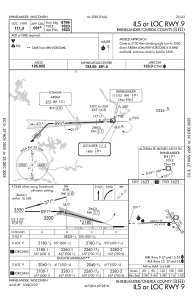
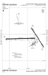
Runways:
| RWY identifier | QFU | Length (ft) | Width (ft) | Surface | LDA (ft) |
| 09 | 88° | 6800 | 150 | CONC | 6799 |
| 27 | 268° | 6800 | 150 | CONC | 6799 |
| 15 | 147° | 5201 | 100 | ASPH | 5201 |
| 33 | 327° | 5201 | 100 | ASPH | 5201 |
Airport contact information
Address: Rhinelander United States
