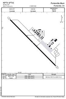


KPTV - Porterville Muni
Located in Porterville, United States
ICAO - PTV, IATA -
Data provided by AirmateGeneral information
Coordinates: N36°1'46" W119°3'46"
Elevation is 443 feet MSL.
Magnetic variation is 15° East View others Airports in California
Operational data
Special qualification required
Current time UTC:
Current local time:
Weather
METAR: KPTV 290356Z AUTO 32004KT 10SM CLR 19/10 A2999 RMK AO2 SLP155 T01890100
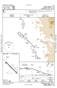
Communications frequencies: [VIEW]
Runways:
| RWY identifier | QFU | Length (ft) | Width (ft) | Surface | LDA (ft) |
| 12 | 135° | 5960 | 150 | ASPH | |
| 30 | 315° | 5960 | 150 | ASPH |
Airport contact information
Address: Porterville United States