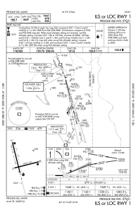
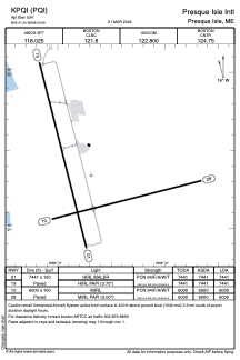


KPQI - Presque Isle Intl
Located in Presque Isle, United States
ICAO - PQI, IATA - PQI
Data provided by AirmateGeneral information
Coordinates: N46°41'20" W68°2'41"
Elevation is 534 feet MSL.
Magnetic variation is -17° East View others Airports in Maine
Operational data
Special qualification required
Current time UTC:
Current local time:
Weather
METAR: KPQI 271556Z AUTO 12006KT 10SM CLR 13/M06 A3043 RMK AO2 SLP334 T01331061
TAF: KPQI 271120Z 2712/2812 VRB03KT P6SM SKC FM272200 14003KT P6SM FEW250 FM281100 16008KT P6SM BKN250
Communications frequencies: [VIEW]
Runways:
| RWY identifier | QFU | Length (ft) | Width (ft) | Surface | LDA (ft) |
| 01 | 346° | 7441 | 150 | ASPH | 7441 |
| 19 | 166° | 7441 | 150 | ASPH | 7441 |
| 10 | 76° | 6000 | 100 | ASPH | 6000 |
| 28 | 256° | 6000 | 100 | ASPH | 6000 |
Airport contact information
Address: Presque Isle United States