


KPKB - Mid-Ohio Valley Rgnl
Located in Parkersburg, United States
ICAO - PKB, IATA - PKB
Data provided by AirmateGeneral information
Coordinates: N39°20'42" W81°26'21"
Elevation is 858 feet MSL.
Magnetic variation is -08° East View others Airports in West Virginia
Operational data
Special qualification required
Current time UTC:
Current local time:
Weather
METAR: KPKB 171253Z 16003KT 5SM BR SCT036 BKN046 BKN100 18/17 A2989 RMK AO2 RAB06E29 SLP118 P0003 T01780167
TAF: KPKB 171136Z 1712/1812 19003KT P6SM -RA SCT035 BKN060 FM171700 22005KT P6SM SCT025 FM172000 21005KT P6SM VCTS SCT035CB FM180000 00000KT P6SM VCSH SCT035 BKN060 FM180300 00000KT 5SM BR VCSH SCT035 BKN050 FM180700 00000KT 4SM BR BKN025
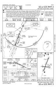
Communications frequencies: [VIEW]
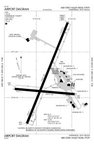
Runways:
| RWY identifier | QFU | Length (ft) | Width (ft) | Surface | LDA (ft) |
| 03 | 22° | 7240 | 150 | ASPH | 6780 |
| 21 | 202° | 7240 | 150 | ASPH | 6780 |
| 10 | 95° | 4002 | 150 | ASPH | 4002 |
| 28 | 275° | 4002 | 150 | ASPH | 4002 |
Airport contact information
Address: Parkersburg United States