


KPAH - Barkley Rgnl
Located in Paducah, United States
ICAO - PAH, IATA - PAH
Data provided by AirmateGeneral information
Coordinates: N37°3'37" W88°46'23"
Elevation is 410 feet MSL.
Magnetic variation is -01° East View others Airports in Kentucky
Operational data
Special qualification required
Current time UTC:
Current local time:
Weather
METAR: KPAH 090053Z 07005KT 10SM VCTS FEW040 SCT080 22/19 A2960 RMK AO2 LTG DSNT NE-S TSB02E45 SLP021 T02220189
TAF: KPAH 090007Z 0900/0924 07007KT P6SM VCTS SCT040CB FM090300 12008KT 6SM -SHRA BR VCTS BKN035CB TEMPO 0903/0905 VRB15G35KT 3SM TSRA BR OVC025CB FM090700 27008KT P6SM BKN250 FM091000 27008KT P6SM BKN015 FM091600 29011G18KT P6SM SCT035
Communications frequencies: [VIEW]
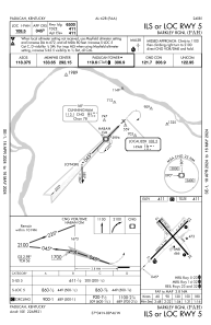
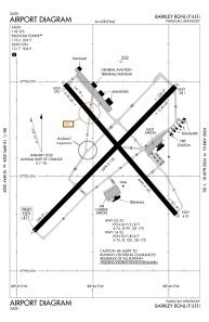
Runways:
| RWY identifier | QFU | Length (ft) | Width (ft) | Surface | LDA (ft) |
| 05 | 44° | 6500 | 150 | ASPH | 6500 |
| 23 | 224° | 6500 | 150 | ASPH | 6500 |
| 14 | 139° | 5499 | 150 | ASPH | 5399 |
| 32 | 319° | 5499 | 150 | ASPH | 5324 |
Airport contact information
Address: Paducah United States
