


KORF - Norfolk Intl
Located in Norfolk, United States
ICAO - ORF, IATA - ORF
Data provided by AirmateGeneral information
Coordinates: N36°53'41" W76°12'4"
Elevation is 26 feet MSL.
Magnetic variation is -09° East View others Airports in Virginia
Operational data
Special qualification required
Current time UTC:
Current local time:
Weather
METAR: KORF 150642Z 11009G17KT 6SM -RA BR SCT005 OVC010 18/17 A2965 RMK AO2 PRESFR P0004 T01780167
TAF: KORF 150520Z 1506/1606 12019G29KT 4SM -RA BR OVC007 FM150900 13009KT P6SM VCSH OVC006 FM151100 19009KT P6SM VCSH OVC006 FM151500 30008KT P6SM SCT007 OVC015 FM160000 01008KT P6SM OVC015 FM160500 01008KT P6SM OVC007
Communications frequencies: [VIEW]
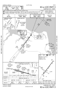
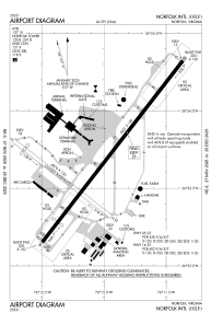
Runways:
| RWY identifier | QFU | Length (ft) | Width (ft) | Surface | LDA (ft) |
| 05 | 38° | 9001 | 150 | OTHER | 7809 |
| 23 | 218° | 9001 | 150 | OTHER | 8995 |
| 14 | 128° | 4876 | 150 | ASPH | 4301 |
| 32 | 308° | 4876 | 150 | ASPH | 3901 |
Airport contact information
Address: Norfolk United States