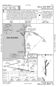
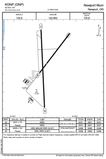


KONP - Newport Muni
Located in Newport, United States
ICAO - ONP, IATA -
Data provided by AirmateGeneral information
Coordinates: N44°34'49" W124°3'29"
Elevation is 160 feet MSL.
Magnetic variation is 15° East View others Airports in Oregon
Operational data
Special qualification required
Current time UTC:
Current local time:
Weather
METAR: KONP 300235Z AUTO 21005KT 10SM SCT038 OVC048 09/05 A3022 RMK AO2
TAF: KONP 292320Z 3000/3024 24010KT P6SM -SHRA SCT025 BKN040 FM300800 22012G22KT 6SM -RA BR SCT025 OVC035 FM301500 22014G24KT 6SM -SHRA BR BKN025 BKN035
Communications frequencies: [VIEW]
Runways:
| RWY identifier | QFU | Length (ft) | Width (ft) | Surface | LDA (ft) |
| 02 | 37° | 3001 | 75 | ASPH | 3001 |
| 20 | 217° | 3001 | 75 | ASPH | 3001 |
| 16 | 177° | 5398 | 100 | ASPH | 5398 |
| 34 | 357° | 5398 | 100 | ASPH | 5098 |
Airport contact information
Address: Newport United States