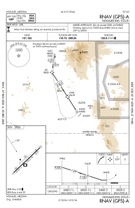


KOLS - Nogales Intl
Located in Nogales, United States
ICAO - OLS, IATA -
Data provided by AirmateGeneral information
Coordinates: N31°25'4" W110°50'52"
Elevation is 3955 feet MSL.
Magnetic variation is 12° East View others Airports in Arizona
Operational data
Special qualification required
Current time UTC:
Current local time:
Weather
TAF: KOLS 282320Z 2900/2924 30008KT P6SM SKC FM290100 31005KT P6SM SKC FM290400 VRB03KT P6SM SKC FM292000 20008KT P6SM SKC
Communications frequencies: [VIEW]
Runways:
| RWY identifier | QFU | Length (ft) | Width (ft) | Surface | LDA (ft) |
| 03 | 46° | 7200 | 100 | ASPH | |
| 21 | 226° | 7200 | 100 | ASPH |
Airport contact information
Address: Nogales United States
