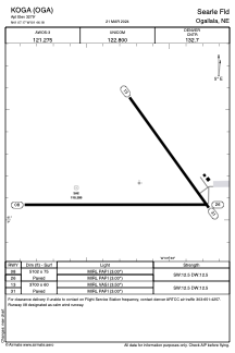


KOGA - Searle Fld
Located in Ogallala, United States
ICAO - OGA, IATA -
Data provided by AirmateGeneral information
Coordinates: N41°7'10" W101°46'11"
Elevation is 3279 feet MSL.
Magnetic variation is 07° East View others Airports in Nebraska
Operational data
Special qualification required
Current time UTC:
Current local time:
Weather
METAR: KOGA 110855Z AUTO 26004KT 10SM CLR 05/04 A3010 RMK AO2 T00500040
Communications frequencies: [VIEW]
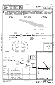
Runways:
| RWY identifier | QFU | Length (ft) | Width (ft) | Surface | LDA (ft) |
| 08 | 90° | 5102 | 75 | CONC | |
| 26 | 270° | 5102 | 75 | CONC | |
| 13 | 144° | 3700 | 60 | CONC | |
| 31 | 324° | 3700 | 60 | CONC |
Airport contact information
Address: Ogallala United States