


KNTD - Point Mugu Nas (Naval Base Ventura Co)
Located in Oxnard, United States
ICAO - NTD, IATA -
Data provided by AirmateGeneral information
Coordinates: N34°7'9" W119°7'11"
Elevation is 13 feet MSL.
Magnetic variation is 12° East View others Airports in California
Operational data
Special qualification required
Current time UTC:
Current local time:
Weather
METAR: KNTD 270455Z 27022G30KT 10SM FEW065 14/10 A2990 RMK AO2 PK WND 28032/0423 SLP124 T01390100 PNO $
TAF: TAF KNTD 2623/2723 27018G25KT 9999 FEW030 FEW065 530009 QNH2984INS TEMPO 2623/2704 28025G35KT FM270600 30012G20KT 9999 SKC 510003 QNH2986INS FM271000 35007KT 9999 SKC 500000 QNH2990INS FM271400 35007KT 9999 SKC QNH2997INS FM271800 27012KT 9999 FEW065 SCT280 QNH2997INS AUTOMATED SENSOR METWATCH 2706 TIL 2713 TX19/2721Z TN09/2713Z FS30183
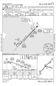
Communications frequencies: [VIEW]
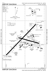
Runways:
| RWY identifier | QFU | Length (ft) | Width (ft) | Surface | LDA (ft) |
| 03 | 44° | 11102 | 200 | ASPH | |
| 21 | 224° | 11102 | 200 | ASPH | |
| 09 | 105° | 5502 | 200 | ASPH | |
| 27 | 285° | 5502 | 200 | ASPH |
Airport contact information
Address: Oxnard United States