


KNKT - Cherry Point Mcas (Cunningham Fld)
Located in Cherry Point, United States
ICAO - NKT, IATA -
Data provided by AirmateGeneral information
Coordinates: N34°54'11" W76°52'51"
Elevation is 29 feet MSL.
Magnetic variation is -09° East View others Airports in North Carolina
Operational data
Special qualification required
Current time UTC:
Current local time:
Weather
METAR: KNKT 141056Z 11004KT 10SM SCT100 19/18 A3003 RMK AO2 SLP165 T01940183
TAF: TAF KNKT 1409/1509 VRB06KT 9999 FEW030 SCT060 OVC100 641109 642004 522409 523309 524201 QNH3000INS BECMG 1414/1416 15012G20KT 4000 -SHRA BR SCT040 BKN060 OVC100 641109 642004 500000 QNH2994INS FM141900 15018G25KT 3200 SHRA BR BKN030 OVC100 641109 642004 QNH2975INS TEMPO 1422/1504 2400 TSRA BR BKN020 OVC080CB FM150500 16009KT 4000 -SHRA BR BKN030 OVC090 600000 QNH2970INS T19/1409Z T22/1416Z
Communications frequencies: [VIEW]
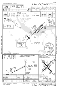
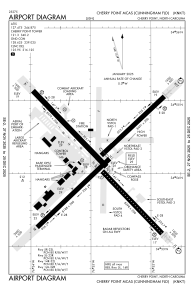
Runways:
| RWY identifier | QFU | Length (ft) | Width (ft) | Surface | LDA (ft) |
| 05L | 45° | 8489 | 196 | ASPH | 7554 |
| 23R | 225° | 8489 | 196 | ASPH | 7554 |
| 05R | 45° | 8189 | 200 | ASPH | |
| 23L | 225° | 8189 | 200 | ASPH | |
| 14L | 136° | 8978 | 200 | ASPH | |
| 32R | 316° | 8978 | 200 | ASPH | |
| 14R | 136° | 8397 | 200 | ASPH | 7549 |
| 32L | 316° | 8397 | 200 | ASPH | 7549 |
Airport contact information
Address: Cherry Point United States