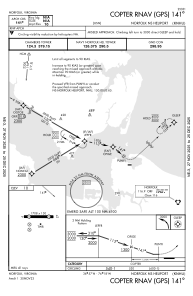


KNHU - Norfolk Ns
Located in Norfolk, United States
ICAO - NHU, IATA -
Data provided by AirmateGeneral information
Coordinates: N36°57'20" W76°18'14"
Elevation is 10 feet MSL.
Magnetic variation is -10° East View others Airports in Virginia
Operational data
Special qualification required
Current time UTC:
Current local time:
Weather at : KNGU - Norfolk Ns (Chambers Fld) ( 2 km )
METAR: KNGU 152359Z 01007KT 340V050 7SM -DZ OVC020 19/17 A2971 RMK AO2 DZB49 SLP059 P0000 60000 T01940167 10222 20194 53009
TAF: TAF KNGU 1523/1623 35008KT 9999 VCSH BKN025 OVC030 QNH2966INS WND 310V050 TEMPO 1523/1605 VRB04KT 6000 -RA BR BKN015 OVC025 FM160500 34009KT 9999 SCT015 OVC025 QNH2968INS TEMPO 1605/1611 VRB04KT 8000 BR BKN015 OVC030 FM161200 33012G20KT 9999 SCT025 BKN040 QNH2972INS FM162000 36010KT 9999 SCT040 SCT250 QNH2973INS TX25/1620Z TN15/1610Z FN00062
Communications frequencies: [VIEW]
Runways:
| RWY identifier | QFU | Length (ft) | Width (ft) | Surface | LDA (ft) |
| 09 | 86° | 1705 | 150 | ASPH | |
| 27 | 266° | 1705 | 150 | ASPH | |
| H1 | 0° | 0 | 0 | UNK | |
| H2 | 0° | 0 | 0 | UNK | |
| H3 | 0° | 0 | 0 | UNK | |
| H4 | 0° | 0 | 0 | UNK | |
| H5 | 0° | 0 | 0 | UNK | |
| H6 | 0° | 0 | 0 | UNK | |
| H7 | 0° | 0 | 0 | UNK | |
| H8 | 0° | 0 | 0 | UNK | |
| H9 | 0° | 0 | 0 | UNK |
Airport contact information
Address: Norfolk United States