
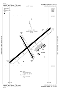


KMVN - Mount Vernon
Located in Mount Vernon, United States
ICAO - MVN, IATA -
Data provided by AirmateGeneral information
Coordinates: N38°19'24" W88°51'31"
Elevation is 480 feet MSL.
Magnetic variation is -01° East View others Airports in Illinois
Operational data
Special qualification required
Current time UTC:
Current local time:
Weather
METAR: KMVN 032056Z AUTO 04008KT 10SM SCT060 24/17 A2997 RMK AO2 SLP149 T02440167 58005
TAF: KMVN 031814Z 0318/0418 05005KT P6SM SCT028 BKN050 TEMPO 0318/0320 BKN028 FM040800 00000KT 2SM BR SCT025 BKN050 FM041300 05002KT P6SM BKN050
Communications frequencies: [VIEW]
Runways:
| RWY identifier | QFU | Length (ft) | Width (ft) | Surface | LDA (ft) |
| 05 | 50° | 6496 | 150 | ASPH | 5722 |
| 23 | 230° | 6496 | 150 | ASPH | 5572 |
| 15 | 150° | 3146 | 100 | ASPH | 3146 |
| 33 | 330° | 3146 | 100 | ASPH | 3146 |
Airport contact information
Address: Mount Vernon United States
