


KMUO - Mountain Home Afb
Located in Mountain Home, United States
ICAO - MUO, IATA -
Data provided by AirmateGeneral information
Coordinates: N43°2'37" W115°52'21"
Elevation is 2996 feet MSL.
Magnetic variation is 13° East View others Airports in Idaho
Operational data
Special qualification required
Current time UTC:
Current local time:
Weather
METAR: KMUO 150155Z 29016KT 7SM CLR 22/01 A2992 RMK AO2A SLP115 T02200005 $
TAF: TAF KMUO 150200Z 1502/1608 30010G20KT 9999 FEW280 QNH2991INS BECMG 1506/1507 30010G15KT 9999 SKC QNH2997INS BECMG 1509/1510 30010G20KT 9999 SKC QNH2997INS BECMG 1515/1516 30010G15KT 9999 SKC QNH2991INS BECMG 1603/1604 30006KT 9999 FEW250 SCT270 QNH2991INS TX24/1522Z TN08/1512Z
Communications frequencies: [VIEW]
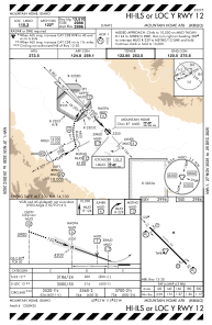
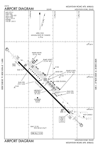
Runways:
| RWY identifier | QFU | Length (ft) | Width (ft) | Surface | LDA (ft) |
| 12 | 135° | 13510 | 200 | OTHER | |
| 30 | 315° | 13510 | 200 | OTHER |
Airport contact information
Address: Mountain Home United States