


KMUO - Mountain Home Afb
Located in Mountain Home, United States
ICAO - MUO, IATA -
Data provided by AirmateGeneral information
Coordinates: N43°2'37" W115°52'21"
Elevation is 2996 feet MSL.
Magnetic variation is 13° East View others Airports in Idaho
Operational data
Special qualification required
Current time UTC:
Current local time:
Weather
METAR: KMUO 012255Z AUTO 31018G23KT 7SM CLR 13/M08 A3003 RMK AO2 SLP174 T01271079 $
TAF: TAF KMUO 011800Z 0118/0224 30015G25KT 9999 FEW040 BKN090 620901 510009 QNH3001INS BECMG 0200/0201 30012G20KT 9999 FEW090 QNH3001INS BECMG 0203/0204 VRB06KT 9999 FEW150 SCT160 BKN200 QNH2999INS BECMG 0208/0209 VRB06KT 9999 SCT080 BKN090 620901 QNH2987INS TX11/0122Z TN00/0211Z
Communications frequencies: [VIEW]
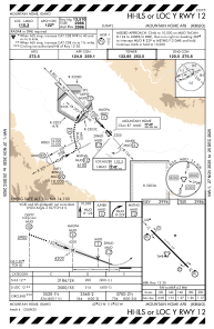
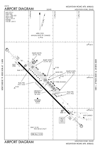
Runways:
| RWY identifier | QFU | Length (ft) | Width (ft) | Surface | LDA (ft) |
| 12 | 135° | 13510 | 200 | OTHER | |
| 30 | 315° | 13510 | 200 | OTHER |
Airport contact information
Address: Mountain Home United States