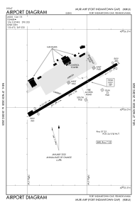


KMUI - Muir Ahp (Fort Indiantown Gap)
Located in Fort Indiantown Gap (Annville), United States
ICAO - MUI, IATA -
Data provided by AirmateGeneral information
Coordinates: N40°26'7" W76°34'7"
Elevation is 487 feet MSL.
Magnetic variation is -10° East View others Airports in Pennsylvania
Operational data
Special qualification required
Current time UTC:
Current local time:
Weather
METAR: KMUI 061726Z 25005KT 7SM FEW006 BKN010 OVC020 19/16 A2998 RMK AO2A SLP154
TAF: TAF AMD KMUI 061725Z 0617/0717 VRB06KT 9999 BKN009 OVC022 QNH2997INS BECMG 0619/0620 VRB06KT 9000 BR OVC010 QNH2992INS BECMG 0702/0703 VRB06KT 9999 NSW SCT020 BKN030 QNH2980INS TX21/0621Z TN16/0711Z
Communications frequencies: [VIEW]
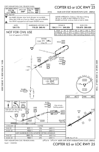
Runways:
| RWY identifier | QFU | Length (ft) | Width (ft) | Surface | LDA (ft) |
| 07 | 60° | 3967 | 100 | ASP | |
| 25 | 240° | 3967 | 100 | ASP |
Airport contact information
Address: Fort Indiantown Gap (Annville) United States