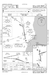
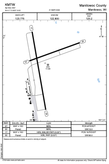


KMTW - Manitowoc County
Located in Manitowoc, United States
ICAO - MTW, IATA -
Data provided by AirmateGeneral information
Coordinates: N44°7'44" W87°40'50"
Elevation is 650 feet MSL.
Magnetic variation is -02° East View others Airports in Wisconsin
Operational data
Special qualification required
Current time UTC:
Current local time:
Weather
METAR: KMTW 291119Z AUTO 15004KT 1/2SM -RA FG BKN002 OVC006 08/08 A2978 RMK AO2 RAB16 P0000
TAF: KMTW 290520Z 2906/3006 13006KT 3/4SM -SHRA BR OVC002 FM290900 14005KT 1/2SM FG OVC002 FM291400 18007KT 2SM -SHRA BR BKN005 FM291800 19012G17KT 5SM -SHRA BKN020 FM292000 23011G17KT P6SM BKN035
Communications frequencies: [VIEW]
Runways:
| RWY identifier | QFU | Length (ft) | Width (ft) | Surface | LDA (ft) |
| 07 | 70° | 3341 | 100 | ASPH | |
| 25 | 250° | 3341 | 100 | ASPH | |
| 17 | 170° | 5001 | 100 | ASPH | |
| 35 | 350° | 5001 | 100 | ASPH |
Airport contact information
Address: Manitowoc United States
