


KMSO - Missoula Montana
Located in Missoula, United States
ICAO - MSO, IATA - MSO
Data provided by AirmateGeneral information
Coordinates: N46°54'59" W114°5'26"
Elevation is 3205 feet MSL.
Magnetic variation is 13° East View others Airports in Montana
Operational data
Special qualification required
Current time UTC:
Current local time:
Weather
METAR: KMSO 280353Z AUTO 00000KT 10SM BKN041 OVC047 08/07 A2992 RMK AO2 RAE13 SLP140 P0001 T00830067
TAF: KMSO 272335Z 2800/2824 25005KT 6SM -RA BKN035 OVC050 FM281100 VRB03KT 4SM BR OVC020 FM281800 00000KT P6SM VCSH BKN050
Communications frequencies: [VIEW]
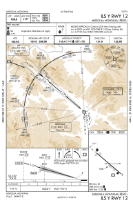
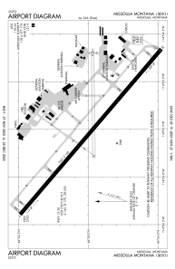
Runways:
| RWY identifier | QFU | Length (ft) | Width (ft) | Surface | LDA (ft) |
| 08 | 89° | 4612 | 75 | ASPH | 4612 |
| 26 | 269° | 4612 | 75 | ASPH | 4612 |
| 12 | 130° | 9501 | 150 | ASPH | 9501 |
| 30 | 310° | 9501 | 150 | ASPH | 9501 |
Airport contact information
Address: Missoula United States

