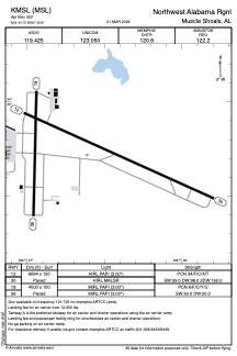


KMSL - Northwest Alabama Rgnl
Located in Muscle Shoals, United States
ICAO - MSL, IATA - MSL
Data provided by AirmateGeneral information
Coordinates: N34°44'43" W87°36'37"
Elevation is 550 feet MSL.
Magnetic variation is -03° East View others Airports in Alabama
Operational data
Special qualification required
Current time UTC:
Current local time:
Weather
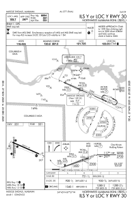
TAF: KMSL 031310Z 0313/0412 20005KT P6SM VCSH FEW035 BKN080 OVC120 FM031600 22008KT P6SM SCT035 BKN050 BKN250 PROB30 0320/0402 4SM TSRA BKN035CB FM040200 20005KT P6SM FEW035 BKN100 OVC250
Communications frequencies: [VIEW]
Runways:
| RWY identifier | QFU | Length (ft) | Width (ft) | Surface | LDA (ft) |
| 12 | 114° | 6694 | 150 | ASPH | |
| 30 | 294° | 6694 | 150 | ASPH | |
| 18 | 181° | 4000 | 100 | ASPH | |
| 36 | 1° | 4000 | 100 | ASPH |
Airport contact information
Address: Muscle Shoals United States