


KMNM - Menominee Rgnl
Located in Menominee, United States
ICAO - MNM, IATA -
Data provided by AirmateGeneral information
Coordinates: N45°7'36" W87°38'19"
Elevation is 624 feet MSL.
Magnetic variation is -03° East View others Airports in Michigan
Operational data
Special qualification required
Current time UTC:
Current local time:
Weather
METAR: KMNM 041957Z AUTO 15013KT 10SM SCT070 BKN090 15/13 A2987 RMK AO2 SLP135 T01500133 $
Communications frequencies: [VIEW]
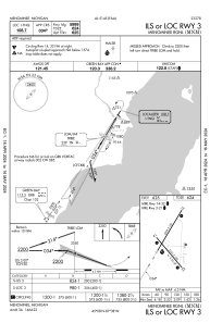
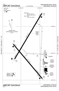
Runways:
| RWY identifier | QFU | Length (ft) | Width (ft) | Surface | LDA (ft) |
| 03 | 31° | 5999 | 100 | ASPH | |
| 21 | 211° | 5999 | 100 | ASPH | |
| 14 | 140° | 5101 | 100 | ASPH | |
| 32 | 320° | 5101 | 100 | ASPH |
Airport contact information
Address: Menominee United States