


KMLU - Monroe Rgnl
Located in Monroe, United States
ICAO - MLU, IATA - MLU
Data provided by AirmateGeneral information
Coordinates: N32°30'38" W92°2'10"
Elevation is 79 feet MSL.
Magnetic variation is 03° East View others Airports in Louisiana
Operational data
Special qualification required
Current time UTC:
Current local time:
Weather
METAR: KMLU 132353Z VRB04KT 10SM -RA FEW100 SCT120 25/22 A2970 RMK AO2 LTG DSNT SE AND S RAB11 SLP057 P0000 60000 T02500217 10267 20239 58012
TAF: KMLU 132333Z 1400/1424 18005KT 6SM -SHRA VCTS SCT025 BKN050CB TEMPO 1401/1404 2SM TSRA BKN025 OVC040CB FM140500 20005KT P6SM VCSH SCT025 BKN050 FM140800 VRB05KT P6SM SCT150 SCT250 FM141200 25003KT 5SM BR BKN007 FM141500 26006KT P6SM BKN017 FM141700 27012G20KT P6SM SCT027
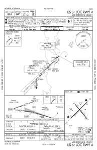
Communications frequencies: [VIEW]
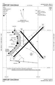
Runways:
| RWY identifier | QFU | Length (ft) | Width (ft) | Surface | LDA (ft) |
| 04 | 45° | 7504 | 150 | ASPH | 7504 |
| 22 | 225° | 7504 | 150 | ASPH | 7504 |
| 14 | 140° | 6301 | 150 | ASPH | 6301 |
| 32 | 320° | 6301 | 150 | ASPH | 6301 |
Airport contact information
Address: Monroe United States